Monday, March 30, 2015

Day 15: Short Day

7 miles: NOC to Sassafras Gap Shelter. 

Today was a short hike but almost 90% uphill. It was also quite muddy and foggy. Towards the end of my hike the weather cleared up and it was sunny the rest of the day. I was the first to the shelter and there I decided to just take it easy since the day before I did 16. Tomorrow I will do a bigger day to make up for today. 

Views of the Nantahala Gorge and the NOC. 

Sometimes people build cool rock stacks on the trail.


Memorial right on the trail.

At the shelter I ate some good food and met a bunch of new people. Very good company here at the shelter tonight. :) We played cards and had a lot of laughs and now I feel pretty refreshed and ready for a new day on the trail. I met Tricks, Stacey, Dabs, Jersey Girl, Burl, and Tree Beard. Lots of new faces, but this is what it's like on he Appalachian Trail. It's one big community with people from every place and background. 

Goodnight!


Experimental trail recipe #1

Since food is one of the main things a hiker thinks about I've decided to do a new category of posts documenting all my experimental trail recipes. Enjoy!

Recipe: Goldfish Ramen Burrito

Ingredients: 
Chicken flavored ramen
Flour tortilla
"Xplosive" Pizza flavored goldfish

Cook the ramen and let the noodles absorb the liquid for a few minutes. Drain a sporkful of noodles and apply to burrito. Half crumble a small handful of goldfish. Roll burrito.
Out of 1-10 I rate this a 4.. Not my best recipe.

Bonus recipe!!
I threw some goldfish in my leftover ramen soup. This was much better than the burritos and I rate it a 6.


Sunday, March 29, 2015

Day 14: Nantahala Outdoor Center

16 miles: Wayah Bald Shelter to Nantahala Outdoor Ceter

Last night was tough. It got very cold. I did stay pretty warm but not comfortably warm. I was the first one out of camp and hiked for about an hour on frozen ground. That was a first for me! I love experiencing new things. I guess that's why hiking out here is so much fun for me. Almost everyday is something new. 


This was a very good day. Had no bad weather and there was about an inch of snow on the ground for about 75% of my hike. This is also my longest day yet. My body feels great I could've done more had the NOC not had a delicious trailside  restaraunt and hot showers. 


Cold Spring shelter.

Snow on almost all the mountains in view.

Fontana lake in the foreground, Great Smoky Mountains in the distance. I hike in the direction of the lake the next two days, and then off and up those mountains.


Really cool water source. Someone had to haul that concrete up the mountain..

This was actually a very steep portion of trail just after what is labeled in the guide as "The Jump Off". 

Part of the Nantahala Outdoor Center, or NOC. It's an "adventure center" for kayaking, rafting, hiking, zip lines, and outdoor education. This is a pretty cool place for ending a 16 mile hike. The trail runs straight through it.

The Nantahala River at the NOC.


Day 13: Snow!!

12 miles: Winding Stair Gap to Wayah Shelter.

(Sorry no map picture as I am missing these couple pages lol)

Today I threw my first snowball!! I've seen snow once before but it melted when it hit the ground. Today was the first time I've seen snow all over the ground all day long. Someone just checked the temperature now at 8:11 pm and its 28 degrees. The sun isn't all the way down yet either. It will probably get down into the teens I'm sure. 


Yesterday after I got picked up from the airport I wasn't able to make it to the trail until really late. So miss Janet let me sleep in her van. It was much nicer in that van than out on the trail last night! I hit the trail at about 1:30 and hiked almost straight to wayah shelter without stopping. Now I'm going to bundle into my sleeping bag and get toasty!! 

Goodnight!


Friday, March 27, 2015

Extra Trail Pictures: NC/TN-Last Update 3/27


Litterbugs.. Please follow Leace No Trace principles in the backcountry. Pack it in, pack it out.


One way to check a hikers backpack for a flight.

Checking a backpack for a flight can be a scary thing. Your home for your upcoming hike is all inside that pack. Not to mention awkward items like trekking poles, hip belts, etc.. Loose straps and webbing can get caught inside conveyor belts and if your backpack is lost or damaged it is even worse for you than it is for a normal passenger. 

When you fly you want to leave any canister fuel or denatured alcohol at home and get it at your destination or mail it to yourself. You could put your backpack in a duffle you don't mind throwing away or mailing home. *Don't discard your duffle in the airport!! It will create a huge security risk for the airport!
OR...
Do this easy but very low class style of checking a backpack:


Make a disposable garbage bag suitcase!


How to:

1) Obtain one of those wonderfully durable and cheap IKEA bags. Or one like it. 

2) Stuff your backpack in the ikea bag and tie the handles.

3) Then stuff the bag into a trash bag and tie the top of it.

4) Double bag it for security. Repeat step 3. 

5) Find a strong packing tape. I recommend filament type (the kind with the string in it that resists breakage). Tape securely.

6) Make handles with the tape wherever desired!

Voila! Disposable durable suitcase!! 

Optional Step: Ignore all the weird looks "fancy" people give you in the airport. 


Thursday, March 26, 2015

Family Emergency Update and New Game Plan

So I had to get off the trail again to celebrate the life of my wonderful grandmother. I left Wednesday morning and will go back Friday morning. She was such a wonderful woman and extremely supportive of everything I've ever done. I would like to thank everyone that has supported me or my family during this time. It has been difficult but it makes it easier when you have such a loving family to go through it with you.


Me and her had a special bond. But then again, she had a special bond with everyone in her life. That's what made her so special. I was her birthday present on January 23, 1991. Ever since then we have shared a birthday full of love and tater tot casserole (our traditional birthday dish). Only a couple of years ago I found out that when I was an infant I almost got sick and it could have been very dangerous for me. She stayed up all night with me and made sure I was ok. She would have done anything for any of her 29 grand children. She was a spectacular grandmother, and that's how I'll always remember her. Now I hike the trail not only for myself, but also for her. She made me promise I would finish the trail for her. She was always ao encouraging! I love that lady! :)


                            ~~~~

On another note. I have decided that the town visits I've experienced so far here in the beginning section of the trail are a bit to full of the greed and consumerism that the trail was created to help you escape. So I am going to stretch the time I go between towns a little farther. Instead of 4-7 days between I hope to do 10-14 days between towns. This will help me get in touch with a little more nature. And  a little less of people that just want to profit off of hikers. But it also means that I have to carry almost double the weight in food. 

Virtual Hike: Hiking in the clouds. (and rain) AT Mile 60.


Because of the low lying clouds in the Appalachian range on rainy days you usually end up hiking in an eerie fog. But that fog is actually a cloud that has shrouded the mountain your on. It makes for a very interesting hiking experience. Because of this nature of storm, its rare when you actually end up in a drenching thunderstorm, like what you experience often in Florida. Most of the time its just this very wet fog.

Hiking all day and getting sweaty and wet can be very dangerous in the mountains. You have to be prepared for unexpected wind chills and cold fronts in these conditions. For safety I hike with all of my gear and dry clothes in waterproof containers (Dry Bags). I always have a warm dry pair of clothes to get into after hiking, as well as a very stable tent, and warm goose-down sleeping bag that will keep my dry and warm as I sleep.

A good example is last year coming out of the Nantahala Outdoor Center (NOC). After the NOC it is about a 6-mile uphill section of trail. I hiked this in a light drizzle, during my hike my rain jacket got me sweaty and my hands were wet from the rain. On the trek uphill it was partly cloudy, with the sun peeking through at steady intervals. Once I reached the top of the mountain, and got on the other side of it, everything was frozen. The trees were leaf-less and icy, an eerie contrast from the bright green foliage on the other side of the mountain. I started to worry because I immediately began to shiver and my hands began to feel extremely cold due to the wetness and the wind hitting them. I started clenching and unclenching my hands on my trekking poles to keep the blood flowing. I zipped up my rain jacket tight even though I was wet underneath; to keep in any warmth I had. Fortunately the shelter was only a half mile down the trail and I made it there in only a few minutes at a slight jog. I was able to immediately change and get into my sleeping bag. After I warmed up a bit I cooked some hot food and was back to normal. I stayed up for quite awhile and watched my first experience with snow drift out of the clouds and gather on the trees and ground. You don't get any snow in Florida. :>

After that day I learned my lesson about how fickle the weather in the mountains can be.

Wednesday, March 25, 2015

Day 12: Franklin, NC

Besides the Budget Inn incident, Franklin was a fun town. We stayed at the Microtel and visited both of the local outfitters who were both extremely nice to us. We did our laundry, took our showers, got our groceries, and drank a couple beers. My dad actually drove up from Florida to get me from here and take me home to be at my grandmothers funeral (see post: Family Emergency Update). So I drove home Wednesday while Ghost, Nine, and Shanna hiked onward. I have hopes to catch up to them again. 
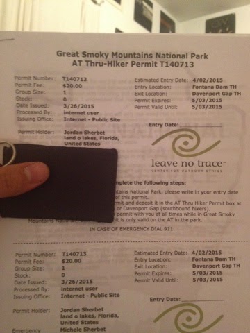
While at home I bought and printed out my smokies permit:


The Great Smoky Mountains National Park is the ONLY section of trail that a thru hiker has to pay to walk. This permit rule was just implemented last year. Most people are expecting more parks to follow suit with this practice.

Snacking at the Ingles grocery store in Franklin NC.


Tuesday, March 24, 2015

Ron Haven and The Budget Inn

The following is my opinion based on personal experience:

Ron Haven...

Owner of the budget inn in Hiawassee, GA and Franklin, NC.
Ex wrestler. 
Ex? Macon county commissioner.


We were trying to find our way to the budget inn from the microtel we were staying at. So we walk to the nearby three Eagles outfitters to ask them about shuttles around town. As soon as we ask, the budget inn shuttle pulls up to the parking lot. So at this point we are thinking "great!". We hop on the shuttle and say hello to the driver which turns out to be Ron Haven. We sit down and before we drive off he asks us if we are staying in town. We reply yes. He says "are you stayig with the budget inn?" And we honestly reply "no we are staying with the Microtel but we have packages at the budget inn." And he immediately says "well than you can get off." I ask him if we can pay for a shuttle to the budget inn so that ghost and nine can get their re supply boxes that were shipped there. He says "no." So we had to walk two miles to get to our re supply boxes.

Now this guy has "trail angel" painted on his van. As well as a sign that says "free hiker shuttle". Also, his van is the same exact van the local public transportation uses, and after asking locals they tell us that the city gives him things like that van to help hikers and get them to and from town. 

A trail angel is an angel. They help hikers when their needed most and never for their own gain. They are amazing men and women that build the community on the trail into what it is.

Now let's examine the services he offers:

Our hiawassee budget inn room had a cold shower, a tv with only 2 buttons (volume up and channel down), dirty sheets and chairs. And our room was missing light bulbs (because apparently "people use them for drugs" according to the house maid) Cost-$55 ("rates vary")

Much the same room if not worse offered in Franklin. All of their rooms have a history of bedbugs according to everybody I asked. Last year at the Franklin Budget Inn my roommate and I were so worried about getting bedbugs there, we covered the beds with our tarps. Cost-$55 ("rates vary").

Microtel: 
Free continental breakfast (x2 if you check in early enough). Hot clean showers. Clean rooms. Clean sheets. Good tv and channels. Professional staff. Cost-$66

My advice:
Do not patron Ron Haven or the budget inn. You will not be helping anyone and will most likely have a bad experience.

Macon county does a three dollar shuttle that runs around Franklin and winding stair gap all day.

In hiawassee stay with either the top o Georgia hostel, or the holiday inn.
In Franklin stay with the Microtel.

Sorry Ron, but you should treat all hikers (and people) with respect. Not just the ones filling your wallet.

Day 11: 100 Miles!

14.7 miles: Carter Gap Shelter To Stealth Campsite at Mile 108.7, just before Winding Stair Gap.


Today was a very nice day. The weather held and was fantastic all day, even though it had rained all through the night. After about an hour we came to a little hole in the rhododendron's that went off to the side and out onto a beautiful overlook.


I just love these mountains because of how often the clouds hang very low in the valleys. It's a really beautiful view.

At this overlook we ran into this very nice young woman named "nine". She hiked out of the overlook with us and joined or little group hiking through the woods. It's crazy how you meet people out here and after a day you feel as if you've been friends with them for a long time. 

After awhile we all came to Albert Moutain. Albert mountain is notoriously steep, but short. At the top is a watchtower that marks the 100 mile point of the trail going northbound. 


Albert mtn view.

After having a very nice break we hiked on to rock gap shelter and had a late lunch. From there we hiked on a few more miles so that we could have a nice an easy descent into winding stair gap tomorrow.

We found a campsite next to some nice college kids from Illinois. They had a huge tent and huge food supply. They had 2  food bags that probably weighed 40 lbs a piece. They put the bags in a canvas blanket they had and tied the corners of the blanket to hang it for a bear bag. After about an hour trying they finally found a tree strong enough and managed to pull it up. Although they could have been much more prepared they were having a great time with their first exposure to the trail! That's what it's all about.

Our campsite that night had a beautiful sunset:


In order of closest to furthest: Shanna, Ghost, Nine, Fozzie.

Monday, March 23, 2015

Day 10: The Return of the Rain

15.3 miles: Bly Gap to Carter Gap Shelter


Biggest day yet. And I feel good.
Today was a good day for hiking. It was cloudy but not raining. But after about 9 miles the rain started. 

This tree right by the border of ga/nc is famous amongst hikers. It's even listed in the guide book.

"The green tunnel"


A rocky downhill section of trail.


And then we summitted Standing Indian Mountain! Our highest yet at 5,498 ft!


First flowers of the season on top of Standing Indian!

At carter gap shelter there are about 30 people. All wanting to go into Franklin tomorrow. Which is 15 miles away. My plan is to camp just before the gap into Franklin and go in the day after, on Tuesday.